
The formation of Cyclone Remal is expected to occur on May 25, however it may occur slightly later than initially anticipated by the India Meteorological Department (IMD). By May 26 at midnight, it is expected to make landfall along the coastlines of West Bengal and Bangladesh, according to IMD.
According to the IMD’s most recent projection, the cyclonic cyclone would move toward Meghalaya and Assam, immediately endangering the Northeastern states with strong winds, heavy rain, and flooding.
Around 4 p.m. on May 25, the storm system was located over the east central Bay of Bengal as a deep depression with winds of 50–60 km/h. By the evening of the same day, IMD predicts it will have intensified into a cyclone and moved northward.
Furthermore, by the morning of May 26, the weather service predicts that cyclone Remal will intensify into a severe storm with wind gusts of up to 115 km/hr. By May 26 afternoon, the wind might pick up strength to 110–120 km/h with gusts as high as 135 km/h.
IMD predicts that at midnight on May 26, the storm will pass over the shores of Bangladesh and neighboring West Bengal as a severe cyclone with peak wind speeds of 120 km/h. Landfall would most likely occur between Bangladesh’s Khepupara and West Bengal’s Sagar Island.
It is anticipated that the storm system would weaken after landfall but maintain its cyclonic strength for at least another 12 hours or more as it moves into Bangladesh. The IMD cyclone report indicates that it can lose more strength and move over to Meghalaya as a low pressure region on May 28.
Cyclone Remal’s forecasted behavior has been erratic. Previous data from the US Global Forecasting System (GFS) indicated that the storm was turning towards Odisha, while data from the European Centre for Medium-Range Weather Forecasts indicated that it was making landfall closer to the coast of West Bengal.
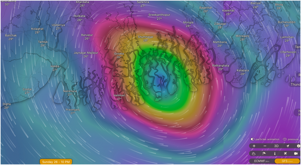
As of right now, the IMD projection indicates that cyclone Remal will make landfall closer to the coast of Bangladesh on May 26 at midnight. The cyclone is presently expected to make landfall on May 26 between Haldibari in West Bengal and Patharghata in Bangladesh between 9 and 10 p.m., according to weather analysis and visualisation portal Windy.com.
Up until now, Cyclone Remal has been crossing the Bay of Bengal at 11–15 km/h, which suggests that it is moving far more quickly than initially thought.
For May 26 and 27, IMD has issued heavy to extremely heavy rainfall alerts for West Bengal’s eastern and coastal districts. On May 26, there’s a chance of exceptionally high rainfall in these places as well. On May 25 and 26, there is also a chance of significant rainfall in northern Odisha.
Following a very dry and highly hot pre-monsoon season, the Northeastern states may also see substantial to extremely heavy rainfall. On May 26, the IMD predicts moderate to extremely heavy rainfall in certain areas of Mizoram, Tripura, and south Manipur.
Heavy to extremely heavy rain is predicted for seven out of eight Northeastern states on May 27 and 28. On May 27 and 28, exceptionally heavy rainfall is predicted over Mizoram and Tripura on May 27, and over Arunachal Pradesh on May 28 in certain regions of Assam and Meghalaya.
According to Raghu Murtugudde, an emeritus professor at the University of Maryland and professor of climate studies at the Indian Institute of Technology, Bombay, “good rains can be expected even if it’s slightly to the east or west since the mountains will extract some rain from the frontend or the tail-end,” Down To Earth reported.
The intense downpours in Meghalaya and Arunachal Pradesh’s slopes may cause landslides, flash floods, and riverine flooding in the area, as well as in Assam. The states are now suffering from extremely dry weather, which might quickly turn into flooding. The state most severely impacted is Mizoram, where there will be a 56% decrease in rainfall between March 1 and May 24. Meghalaya is 53 percent behind in the same
[…] On May 26th, Cyclone Remal is expected to make landfall; flooding in the Northeast is possible. […]